
Reading Time: 5 minutes
After setting up remote cameras before a SpaceX rocket launch from Vandenberg Space Force Base, I came to this location for a hike. The rocket wouldn’t launch until the next day and it was such a beautiful day in the area. I come to this area a lot because of the rocket launches and during that time, I try to explore more of this region.
Location
Nojoqui Falls Trail & Park (pronounced na-hoo-ui) are located in Santa Barbara County. It’s about a 2.5-hour drive from Los Angeles and almost 5 hours from San Francisco. Most of the drive to the park will be on scenic Highway 101. When coming from LA, the off-ramp is about 10 miles after you passed through the Gaviota Pass Tunnel. Only a small sign indicates the existence of this park when traveling on Highway 101. Follow Old Coast Highway for about one mile and then make a left on Alisal Road. From here it’s about another mile to the park entrance which will be on your right. You can use Google Maps and it will take you right to the park.
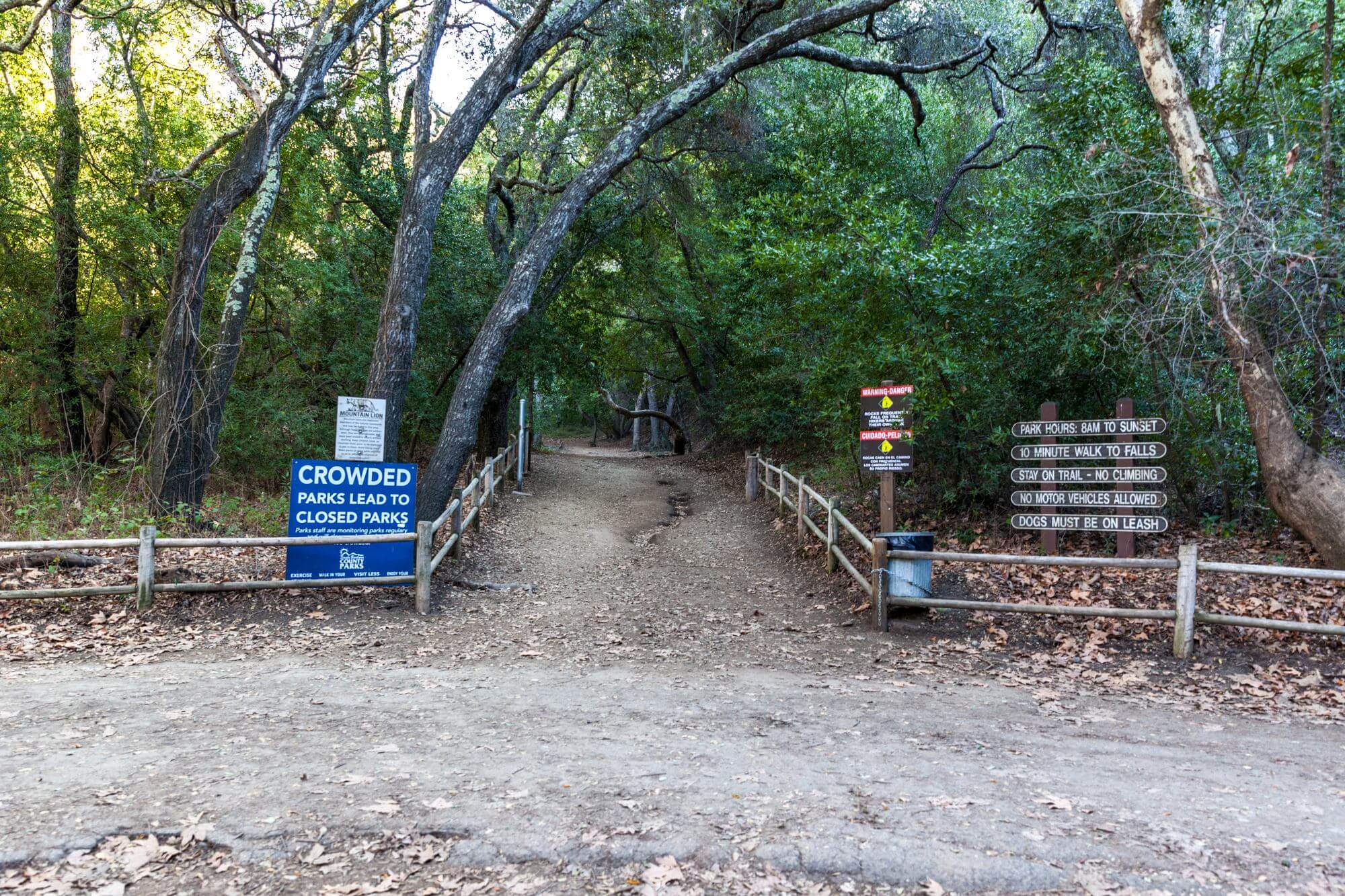
At first glance, the Nojoqui Falls Park looks just like your average city park with sports fields, barbeque grills, and group picnic areas. The secret, the waterfall, is tucked away towards the back of this park. When you enter the park grounds, follow the road all the way to the end to reach the trailhead parking lot. Compared to the other parking lots in the park, this is a dirt parking lot.

The park is open from 8 a.m. to sunset and no fees are required for parking and hiking. However, there are a few reservable areas for group picnics and barbeques. These areas need to be reserved for a fee.
Trail Map
Nojoqui Falls
Trail and Waterfall
The terrain in the parking lot is a bit rough. Be careful when driving and parking if you don’t have a lot of clearance. Near the trailhead is a restroom facility. This is one of the multiple restroom facilities throughout the park.
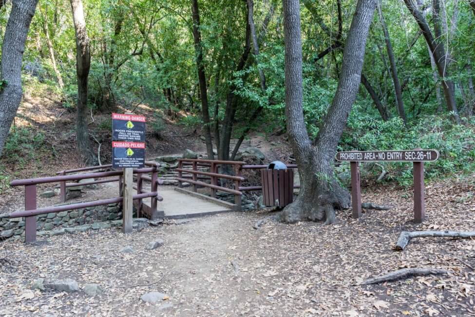
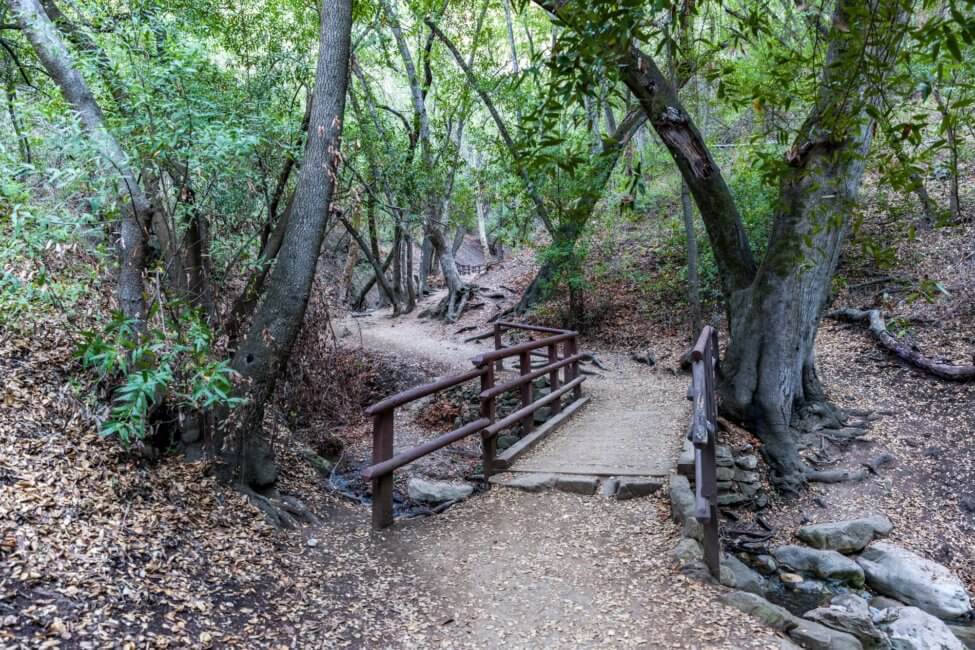
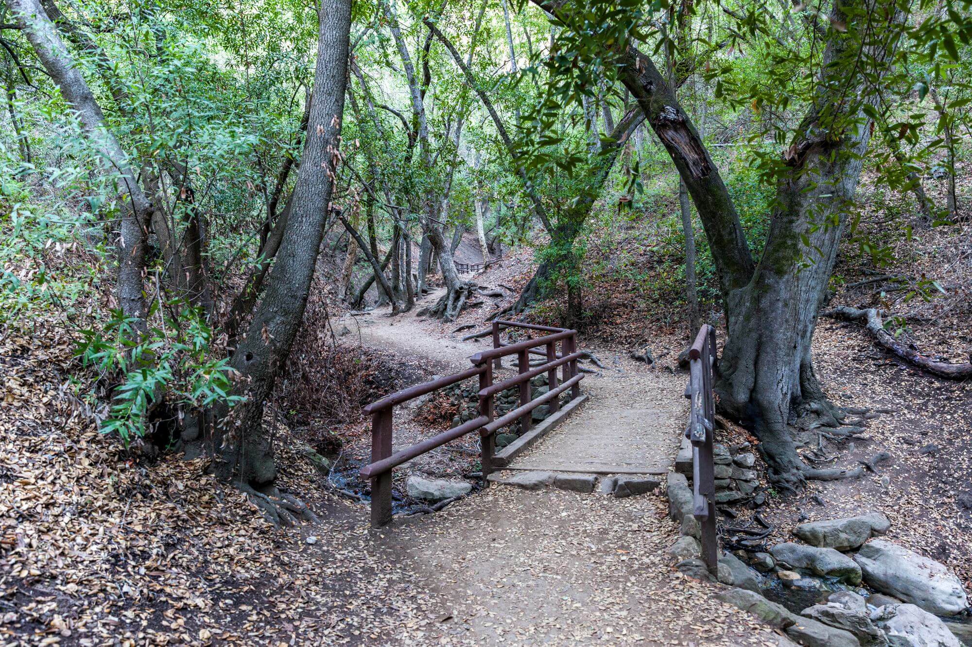
It is a very short hike from the trailhead to the parking lot. With a moderate walking speed, it will take you about 10 minutes to reach the waterfall. On your way, you will cross three bridges over a small creek that runs down all the way to the parking lot. Nearly the entire trail is in shade, which makes it a breeze during the hot summer days. Along the trail are a few park benches, which makes it great for a small picnic.
First I was worried when I got on the trailhead and saw the creek dried out. Is the waterfall dried up as well? I took my chances to hike to the end either way. Once you get closer and cross the last bridge, you can actually hear and see the water in the creek. It veers off near the bridge closest to the parking lot and that’s why you don’t get to see water there.
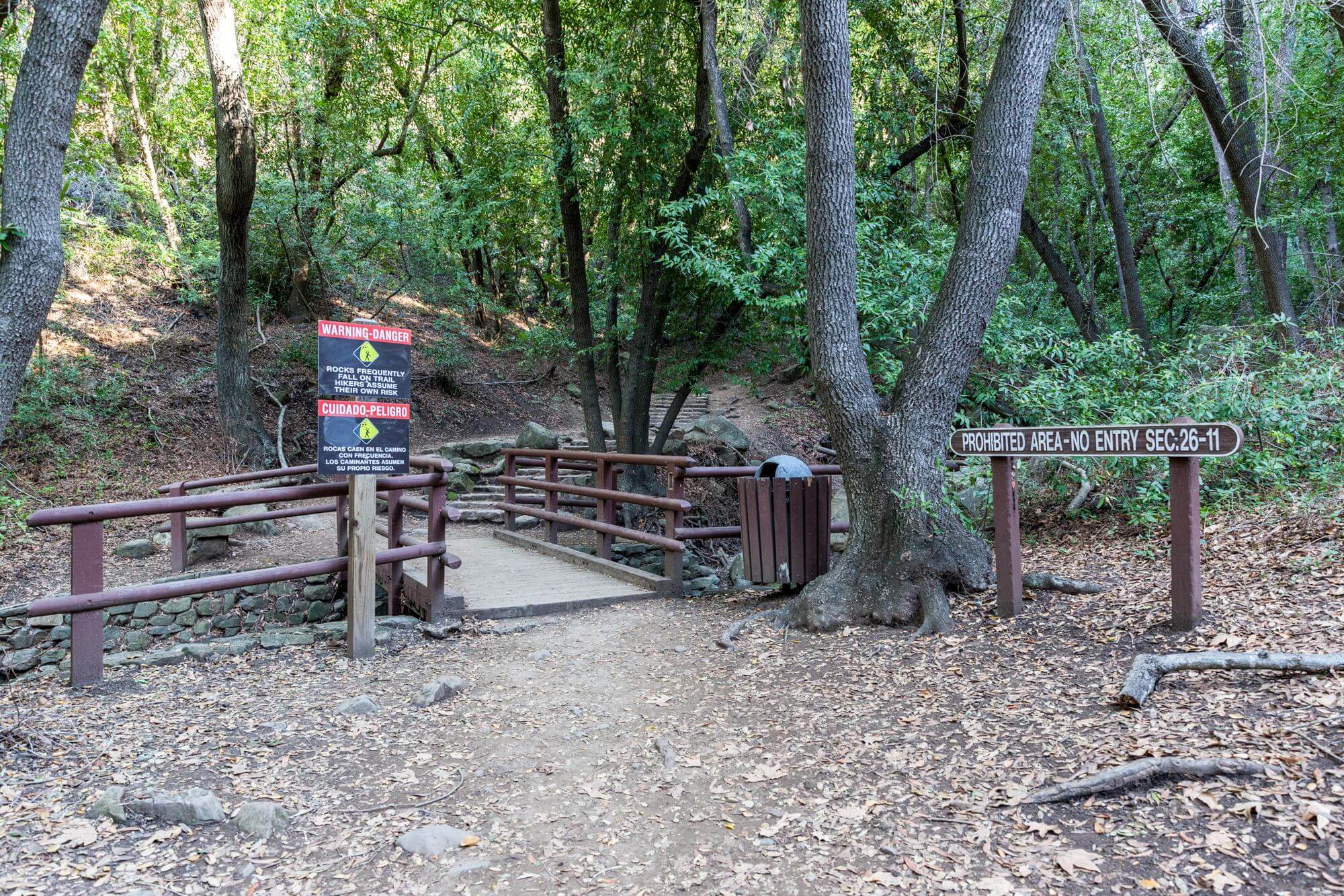
However, very close to the waterfall the trail is barricaded off by park workers for safety. There was a landslide in 2007 (year unconfirmed) which led to this barricade being put in place. You can see that people already made their own path past the little barricade. Be careful when taking that trail as it is close to the creek and if you trip, it will hurt.

Once passed the barricades, you walk around the bend and the majestic waterfall is right in front of you. Well, majestic might be an overstatement, but the waterfall is still pretty to look at. Water drops about 80 ft down and then follows the creek. Most of the year, just a small stream will run down the face of the waterfall which splits into two parts at the top. I love how the ferns paint the front of the cliff green. During the rainy season and after heavy rainfalls the water flow increased drastically and you can hear the water roar over the cliff’s edge tumbling down into the creek from even further away.
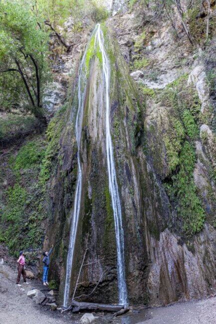
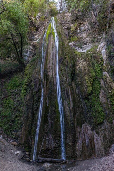
There used to be a pool directly under the waterfall which got filled in during the landslide. You can still see the aftermath of the landslide when you look on either side of the waterfall. Especially on the left hillside, you can see how the ground just slid down into the waterfall basin. Please stay off the sides, as they are very unstable. I talked to a local who I met hanging out at the waterfall and she told me about the landslide and how amazing the pool was back then.

Take the same way back to the parking lot and remember to take out all your trash, leave no trace and just take photos.
Gallery
Conclusion
This is a very easy trail and suitable for every skill level. You have a slight elevation gain on your way to the Nojoqui Falls. Overall most of the trail is flat and easy to walk on. There are a few steps along the way, but nothing major. Stay on the trail to not damage the surrounding habitats. What was your experience while visiting the Nojoqui Falls?
By the way, because you are already in the area. Check out the Gaviota State Park & Beach nearby. There is a picturesque and historic railroad trestle which you might find interesting to visit.

Peter has a passion for Traveling, Photography, and Geocaching. These are the best ingredients for amazing adventures all over the globe. “Traveling is fun, no matter if you stay in a luxury hotel or travel like a backpacker.” Peter shares his experiences on his Blog www.gatetoadventures.com
Some of Peter’s photos are published on corporate websites, in-flight magazines, travel guides, and much more.

